


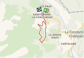
Sainte Anne

jps13
User

Length
5 km

Max alt
1995 m

Uphill gradient
193 m
Km-Effort
7.6 km

Min alt
1813 m

Downhill gradient
191 m
Boucle
Yes
Creation date :
2025-03-03 09:54:09.0
Updated on :
2025-03-03 14:52:44.007
1h42
Difficulty : Easy

FREE GPS app for hiking
 SityTrail
IGN / Geographical institutes
SityTrail Plus
The world is yours!
About
Trail Snowshoes of 5 km to be discovered at Provence-Alpes-Côte d'Azur, Alpes-de-Haute-Provence, La Condamine-Châtelard. This trail is proposed by jps13.
Description
Boucle avec pause dej au restaurant d’altitude
Positioning
Country:
France
Region :
Provence-Alpes-Côte d'Azur
Department/Province :
Alpes-de-Haute-Provence
Municipality :
La Condamine-Châtelard
Location:
Unknown
Start:(Dec)
Start:(UTM)
318705 ; 4926367 (32T) N.
Comments